OLDHAM RANGE POLYMETALLIC PROJECT
In December 2021 Meryllion announced that it had entered into an option agreement with Matlock Geological Services Pty Ltd (“Matlock”) in respect to E69/3461 covering approximately 147 km2 of tenement area prospective for copper-nickel-cobalt-PGEs and zinc. (“Oldham Range” or “the Project”). The Project is located 320 kms west of Wiluna in Western Australia. Polymetallic base metal grades of up to 0.11% copper, 800 ppm zinc and 180 ppm lead received from several rock chip samples, between 8 - 10 times the background values.
Meryllion has been working to secure Aboriginal Heritage Clearance to allow for exploration drilling. CO-FUNDING APPROVED BY WESTERN AUSTRALIAN GOVERNMENT FOR UP TO AUD$150,000 FOR DRILLING AND UP TO AUD$15,000 OF MOBILISATION. Meryllion has evaluated sites for the proposed initial drill program, subject to all relevant authorities and stakeholder approvals.
Meryllion could earn a 100% interest in the Project by spending AUD$300,000 on exploration, based on an agreed budget, on or before, 31 December 2021. This date was subsequently extended by mutual agreement to 31 December, 2022. Following the minimum expenditure being met, Meryllion will have an exclusive right to acquire the Project at any time subject to:
- Issuing 2,000,000 MYR shares
- Payment of AUD$50,000
- Granting a 1% Net Smelter Royalty for all metals produced from the Property
Due to the increased exploration activity in Western Australia and requirement to seek all regulatory approvals for drilling, Meryllion and the optionor are working together and agreed to extend the option period to 31 December 2022 to enable the parties to obtain a suitable drilling rig and complete necessary regional approval.
TECHNICAL OVERVIEW
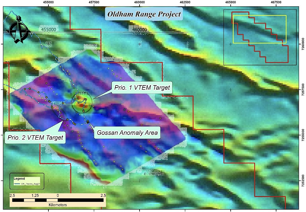
The Company engaged RockDomain Consulting Pty Ltd (“RockDomain”) to carry out a technical evaluation and assessment of the geological setting, mineralisation, and results of the historic work programs. RockDomain provided a technical report following a site visit and an assessment of the prospectivity of the Project area and recommended follow up exploration tasks.
During August 2021, the consultants undertook a geological reconnaissance and rock chip sampling campaign over the project area. Several geological traverses were undertaken across the areas identified as most prospective. Seventeen (17) rock chip samples were collected and submitted for analysis.
The project area covers approximately 147 km2 and is located in the central eastern part of Western Australia about 320 km northeast of Wiluna (Figure 1). The data considered for the assessment included, historic data, mapping and field observations, rock chip sampling and geophysical data. The aim was to provide an independent opinion of the style, distribution, geometry and controls on mineralisation as well as an assessment of the litho-stratigraphic succession for an improved geological-structural model to support future exploration.